Day 4 – Huntstile

thumbnail imageFirst up an apology to all of those eagerly anticipating another day of following our epic journey. Oops, I forgot to turn the live tracker on! It was pouring with rain when we set off OK?

What a fab fab day despite the weather’s best attempts to drown us at various intervals. Not too impressed with the torrential (there cannot be enough emphasis on the word torrential) downpour just 10 minutes from camp.

Back to the beginning. The YH was stuffed full of end to enders (there were two others) and Sam chose to spend the day with us despite our slowness potential. He was heading to Cheddar. Great lad and great company. We had an ace day, cheers Sam. I hope my navigational skills were good enough!

After finding our way out of Okehampton, which wasn’t that easy, after an initial climb it was downhill all the way nearly and we ate up the miles. It wasn’t long before we were just a mile from Crediton when BANG one of Andrew’s spokes snapped (did I forget to mention that he was the first faller yesterday when he forgot his bike is wider with panniers on?).

No worries, Crediton has a brill bike shop that put the kettle on for us while they fixed it. They also provided some useful route advice. Cheers Bike Shed.

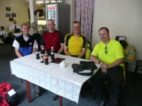
We headed for Cullompton for lunch and just before we saw one of the Ice Trikes of Ben and Donald ahead. It was Ben on his lonesome and we found a caff for a chat and a bite to eat. I hope Ben found Donald again! The picture is Sam, Andrew, Me and Ben.

After some navigational twists and turns we eventually found the NCN 3 which followed little lanes into Taunton and then forgot to signpost us out again. Hmm, we negotiated the rush hour traffic instead and rang ahead to Huntstile Organic Farm for camping.

What an excellent location. We appeared like drowned rates but the coffee was on before we could hardly say hi. Great hosts have plied us with beer and conversation. Full English for brekkie tomorrow, that must be better than cold left over pizza like this morning? Not sure we’ll be able to move afterwards though!

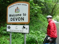
Where was Devon? That was easy peasy, what’s next?! It would be nice, pretty please, for a drying day.

Distance : 72.96 miles
Time cycling : 6h28m
Ascent : 1677 m
Average speed : 11.3 mph

Day 3 – Okehampton

thumbnail imageAfter the evening’s children’s entertainers at the holiday camp it was off to the tents to be kept awake most of the night by the light above the tent and the wind.

I was feeling rubbish in the morning and it was cold and windy. I packed rather haphazardly and we set off. After the few miles to Padstow the cobwebs were blown away though.

We followed the Camel Trail from Padstow through Wadebridge to Wenford Bridge which was very pretty and well surfaced. A few heavy showers didn’t deter us. It was a little muddy in places due to the rain.

We stopped for some lunch at the Post Office in St Breward (highly recommended) before the fantastic scenery and minor roads over Bodmin Moor.

We kept to minor roads as much as possible to Launceston (pronounced Lans-Ton) apparently. After a minor navigation error into the industrial estate we found the way out of town and over the River Tamar and into Devon. That’s Cornwall done and not the hilly nightmare we were warned about. We hope Devon isn’t too bad!

We stopped for a cream tea in Lifton just as the heavens opened. A lucky break we thought until shortly after resuming they opened again.

The old A30 was busy with fast traffic and pretty miserable in the wet but we got to Bridestowe and climbed the rough track onto the Granite Way for a fab run into Okehampton.

The YHA guy then sent us into town and back out again up a really steep hill back past the Granite Way! We’re camping at their out of town hostel which is nice and warm and I can charge everything up.

Neither of us are having any problems with the cycling yet. It’s going ace!

Distance : 68.06 miles
Time cycling : 6h33m
Ascent : 2476 m (allegedly)
Average speed : 10.4 mph

Day 2 – Harlyn Bay

The weather during the night was atrocious. Heavy rain and strong winds. The thought of losing the tents on the first night crossed my mind as I lay awake.

They survived but we woke to wind and rain and had to pack up in the wet. It was full waterproofs weather and it was torrential during the short cycle to Hayle on the A3074.

By some miracle however it blew over and the Sun came out so that we removed our waterproofs before we’d even got to Portreath. The rest of the day was mostly sunny with very brief heavy showers. The very strong southwesterly was still with us helping us along the way.

We had our first navigation error in Porthtowan, only minor but I think it gave us one extra steep climb.

We stopped for lunch in Perranporth. The cycling had been pretty straightforward to this point, not really any of the dreaded Cornish hills to worry about.

They came between St Newlyn East and Rumford. Up and down with some fairly steep ascents. Nothing really bad though. We stopped for supplies in Treyarnon and loaded with food bags stopped at the first available campsite which is a rather tacky holiday camp. Never mind, it was cheap and we’ll have better some nights I’m sure.

Distance : 51.80 miles
Time cycling : 4h58m
Ascent : 1382 m
Average speed : 10.4 mph

Day 1 – St Ives

thumbnail imageWe’re off! The train journey was long and dull and we got stung for excess fares as there were only two of us on a party saver ticket. Ho hum. We did say hi to Andrew and Peter who joined at Swindon and were starting their end to end today.

Penzance was very windy and quickly left behind as we retrieved our bikes and headed into the wind on the NCN 3.

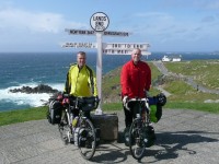
This part of the journey seemed fairly pointless as we hadn’t really started yet. We followed the NCN route all the way to Sennen via Mousehole and St Buryan. About 15 miles later we were at Lands End having our photo taken and formally started LEJOG 2009!

We chose to take the B3306 to St Ives which we had been warned was hilly. With a very strong tailwind though it was fantastic cycling with only two short climbs to trouble us. The weather was brill, sunny, cool with the odd brief heavy shower which the wind soon dried.

Found a great campsite in town and walked down the hill to eat. A great start to the adventure, long may the good days last!

Distance : 19.62 miles
Time cycling : 1h47m
Ascent : 445m
Average speed : 11.0mph

The Adventure Starts Here

Packed. Ready. Let’s Go!

I hope the website all works for the trip. Thanks for visiting and enjoy following us, and thanks to all of our sponsors. Got to be up for the train in a few hours.

Last Few Days

Both riders took it easy for the final weekend before the off. I did 14 miles with the family along the NCN 5 and 44 to Didcot and Upton at a nice gentle pace. The bike also got cleaned and polished. I cycled to work yesterday, hope the wind dies down or changes to another direction for Saturday! Actually the forecast is nowhere near as bad as it was earlier, not too bad at all now.

I’ve added my Twitter to the site, it’s not all LEJOG at the moment as you will see, I’ll try and tweet on the road when I can. It really depends on mobile battery power and how much I need to conserve juice. The Live Tracker should all be working, it’s not given me any problems the last few times we’ve been out, so I’m hopeful all the technology will work. I’ve also added a few other blogs to your left mostly of guys who are end to ending at the same time as us.

I’ve added the route to my GPSr (Garmin Geko 201) in ten chunks of 500 points each (the maximum it can hold) thanks to CourseCompacter, so that should be OK. Andrew has a copy on his Garmin too. I also have printed out a full set of paper maps, mostly at 1:250k scale with some 1:50k for the cities/tricky bits. Quite a few to start with but I will throw recycle them as they get used.

I think we’re ready, I’ll get packed up over the next couple of evenings. Nothing left to get I think…

Route Changes

I’ve finalised the probable route for the LEJOG now. Including some major changes in the southwest. We’re now going to do a more north coast route via St Ives, Hayle and Perranporth.

The idea is to join the Camel Trail at Padstow and follow that to Wenford Bridge before skirting Bodmin Moor and heading along the old A30 to Okehampton.

After that the route is similar to before, it now goes through Bristol and over the Clifton Suspension Bridge and a more easterly route near the Welsh Border through Leominster and Ludlow. North of this the route is identical to before apart from a slight reroute through Blackburn and Carlisle.

The distance is about the same but the ascent has reduced a bit. We’re also planning to do a short first day to St Ives from Land’s End if the train is on time!

News Update

No training over the Bank Holiday as it was time for family things before we’re off. Both riders did some bike tweaks and checked their packing arrangements though. We also went to the Middle Barton pre-school féte to collect some sponsorship for Andrew. We are extremely grateful to all the kind people who have donated money to our charities and we have both raised amazing totals so far.

This weekend we might do the Classic Oxfordshire ride but no other plans. The forecast for the following weekend and first week of our ride is ‘unsettled’. Boo.

Training 26th Apr

Riders John & Andrew
Distance 70.25 mi
Time 6h56m25s
Average Speed 10.12 mph
Ascent 1717 m
Run.GPS Training Profile

The night was chilly, needed two layers to keep warm and we were a little surprised to see frost on the tents! But we rose at 7.30am, breakfasted, packed up and we were away on the return leg of our journey.

We were concerned we might have to push up the track from the YHA but it’s not too bad, it seemed steeper going the other way. Once at the top it was a fast descent to Goodrich and back across Kerne Bridge. We were doing a different route home and I had concerns that it was going to be hilly, especially near the beginning, we were further south from Ross and the hills there are bigger. There was a massive climb from the Wye Valley to Ruardean, it was very very long and pretty steep in places. It was virtually never-ending. We got to the top though and descended into Drybrook to have to climb back up to Mitcheldean.

We had a few miles on the A4136 and that had a short but nasty climb too, especially as it was on a fast three lane road. We stopped for a breather before attacking it. After Huntley we were back on minor roads to Tibberton again. The B4215 is not the most pleasant cycling road, very busy with traffic it must be a main route from Gloucester to Newent and beyond.

We wanted to avoid the A40 so we followed the signs for cyclists to get to Gloucester, there was a farm shop at Over where we could get a coffee and cake. Another NCN nightmare followed sadly. The signs for cyclists totally vanished and it didn’t seem that Gloucester wanted to welcome cyclists at all. After going under and over a few bridges we finally spotted an NCN sign which took us under a barrier which was too low for the bicycles to get under. After dismounting and getting the bikes through we were apparently in the middle of a waste tip with no real path to speak of. We followed the NCN signs though and a few hundred metres later tarmac appeared, did they run out of money?

Following the NCN signs we eventually got to the docks (one flight of steps later as well BTW). That’s when the signs disappeared again so we just sodded it and stuck to the roads to get into Gloucester. A very confusing sign before the pedestrian zone made it as clear as mud whether we were allowed to cycle or not. Half expecting an on-the-spot fine we cycled through anyway. We followed the long straight road to Brockworth over many sets of lights and glad to be out of the city that doesn’t seem to welcome cyclists at all.

The unfortunate thing about crossing the Cotswolds from west to east is that you have to climb the scarp slope somewhere. The chosen route this time was up Birdlip Hill. Very long and very very steep, the signpost at the top says 1:6 and it’s a prolonged gradient. What started as a 3-stopper, turned into a 10-stopper as we took it a hundred metres or so at a time. We also had a longer break nearer the top. Not recommended fully laden! I hope there aren’t too many of those on LEJOG!

We were pretty pooped by now, there’s only so long you can cycle on two bowls of cereal and a Mars Bar so we wanted some lunch badly. Birdlip didn’t deliver and only minor hamlets followed until we got to the A435 at Colesbourne. Thanks goodness there was a filling station and shop, they had no filled sandwiches but they did have one sausage roll, some bread and cheese. We improvised some filled rolls and ate sat on the wall of the forecourt. After a rest (lovely toilets in the filling station BTW!) we were off again.

Another steep climb up and over the ridge to Withington and along the Coln valley past Chedworth Roman Villa and Yanworth. Yet another steep hill to get to Northleach which had another steep hill to get out of it again. Finally we were in the Windrush valley and we could relax a bit as we headed home. After a brief stop in Windrush we had a modest climb above Taynton before my favourite section of the ride. The B4427 into Charlbury, mostly downhill with undulations you could speed down and use momentum to get back up the other side. We got some speed up on the smooth surface and were happy again for a bit.

One last hill out of Charlbury and along B-roads and to the finish.

This was one hell of a hilly ride it has to be said, the ascent is close to 2000m and there were two really big 300m climbs in there. They really took it out of us and we were tired and a bit saddle sore by the time we finished. A really tough fully laden test and hopefully about as bad or worse than anything we could experience on LEJOG. We also did a few too many miles on each day, and we’d be better off sticking to about a 60 mile limit on tough, hilly days.
Training 25th Apr

Riders John & Andrew
Distance 73.53 mi
Time 6h36m24s
Average Speed 11.13 mph
Ascent 1297 m
Run.GPS Training Profile

This was our test run. Fully laden, camping, a there and back trip. We were heading for the Wye Valley and the weather couldn’t be much better, fine, mostly sunny with a southerly breeze and not too hot.

We set off from Andrew’s house (see photos of us posing before the start) and headed west into the Cotswolds. Sticking to minor roads almost exclusively we skirted south of Chipping Norton and north of Stow-on-the-Wold. The ride was undulating but nothing untoward. Downhill runs fully laden are exhilirating, the bike is stuck to the road and you feel much more secure without it skipping about. We stopped in the superbly picturesque village of Guiting Power for a coffee and croissant. Fresh from the oven and still hot. Yummy.

We then needed to climb steadily to the top of the scarp slope above Winchcombe and a fantastic drop down into the busy, but pretty, town. Disgusting public toilets though. We followed the route of the Gloucestershire steam line through Gretton and Gotherington before we stopped in Bishop’s Cleeve for lunch. There was a wide range of eateries in the town and they must face a lot of competition from each other. We elected for a jacket potato from a caf